Repository navigation
Tutorial 09 Exploring the world
Part of the tutorial: page 9 of 12
▶ Watch this page: part 9 of the tutorial video (about 2 min), with narration and subtitles.
Read what the generator worked out about your world, see it as it was in an earlier age, and time a journey across it.
Start from: 08-places-and-labels.json, the map as it is at the end of Tutorial 08 Places and labels. Download it, then open Maps on the rail and click Import JSON; the map is listed under its name, and Load opens it. Or carry on with your own map from Tutorial 08 Places and labels.
A run of Generate works out more than it places on the map: how many people live on every part of the land, which people they are, how much trade passes along each route, and what the world was like in each of its ages. The thematic layers, in the map controls, draw those figures over the map. The History and Travel tools, in the Explore stage of the rail, are for looking at a finished world: History shows it as it was in an earlier age, and Travel shows how long journeys take. None of them changes the map.
-
In the map controls at the foot of the map, open the Regions menu and untick Fills, so the realms' colours don't tint what comes next. Then open the Thematic layers menu and choose Population. The land is coloured by how many people live on it, from the empty wilds (palest) to the crowded farmland round the cities (darkest red). Point at the land near Mostadra: the information bar reads the population there, and the legend marks it on its scale.
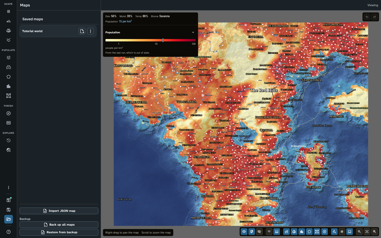
Population, with the information bar and the legend reading the land near Mostadra.
Capacity shows how many people the land could feed, on the same scale, so where Capacity is darker than Population there is room for more. Cleared land and Danger show the farmland and the toll of raiding and strife. Opacity, at the foot of the menu, sets how strongly a layer covers the map.
-
In the Thematic layers menu, choose Culture. Each part of the land takes the colour of the people most of its folk belong to: the Hillfolk's blue across the north, the west and the hills, the Valefolk's gold in the east and the south, paler where the two live together. Point at the Red Hills: the information bar names the people and their share.

Culture: the Hillfolk and the Valefolk, with the information bar reading the Red Hills.
-
In the Thematic layers menu, tick Trade. The trade the run carried is drawn along its routes: the wider the line, the busier the route, and its colour shows how the goods travel (orange by road, green by river, purple by sea). Zoom in on the east of the continent to see the trade between the Red Hills, the coast and Islemark.

Trade over the Culture layer: roads in orange, rivers in green, the sea in purple.
Trade can be shown beside a colour layer, as here, or on its own with the colour layer set to None.
-
Untick Trade in the Thematic layers menu. Then click Reset view, and click History in the Explore stage of the rail. The world was made in two ages, and History opens on the first, Age 1, early medieval and peaceful: the map shows that age's realms, towns, roads and names, and the Culture layer shows its peoples. The whole land is Valefolk: the Hillfolk only arrive with their invasion in the present age.

The world in Age 1, with its realms, places and peoples.
-
Click Age 2: the present in the Ages list, and compare: the invading Hillfolk now hold the north, the west and the hills. Scroll the panel down to What changed, which lists, since the age before, the realms that fell and rose, the places founded and lost, and each people's share of the land: the Hillfolk from none of it to 64%.

The present, with what changed since Age 1.
Export to PNG at the foot of the panel saves the map of the age shown, named with the age, so a set of images can tell your world's story.
-
Click Travel in the Explore stage of the rail; the first time, it takes a moment to work out the map's travel network. Choose By wagon under Way of travel, then click Kansmarda on the map to start the journey there. The land is coloured by the days it takes to reach, in bands of ten days, and a numbered line marks the edge of each band. Point at Newcested on Islemark: the way there is drawn on the map, by road to the coast and then by ship, and the information bar gives the time: a little over 33 days. A world map is large, and a wagon is slow.

By wagon from Kansmarda: the day bands, and the way to Newcested.
Try On foot: a wagon is quick on the roads and slow off them, so its bands stretch along the roads, while a walker's spread more evenly. While Travel is open, its day bands take the colour layer's place, and Opacity in the Thematic layers menu sets how strongly they cover the map.
-
Set the Thematic layers menu back to None, tick Fills again in the Regions menu, and save the map. The layers, the age you chose and the journey are saved with the map, so each opens where you left it.
The map as it was at the end of page 8, with the region fills on and no thematic layer. The Travel tool opens on the journey from Kansmarda by wagon.
To compare your map with the tutorial's, or to start the next page from exactly this map, download 09-exploring-the-world.json and import it in Maps with Import JSON.
Everything on this page is the same in Foundry. A thematic layer that is on when the map is exported to a scene is drawn into the scene's image.
The thematic layers come from the last run, so generate again after big changes to the land (the Generate panel says when the map is out of date). For a world with history, give the run several ages and a culture event, then step through them in History with the Culture layer on, and export each age for your players. Use Travel to set the pace of a campaign: a 10-day band on a world map shows how long a realm takes to cross, a 1-day band on a regional map a day's march from a town. A road you draw counts at once, so Travel also shows what a new road would change. See Map Canvas (thematic layers), History and Travel.
Next: Tutorial 10 Finishing and sharing
Related: Map Canvas, History, Travel, Cultures