Repository navigation
Named Places and Track Markers
Named Places associates a readable name with a map location and a matching radius. A place can apply to every vehicle or only one vehicle. Track roles also identify start, finish, and timing locations for track analysis.
- Open Settings → Named Places.
- Choose All vehicles or a specific Vehicle.
- Enter its Name.
- Enter Latitude and Longitude, or choose Pick on Map to select a location.
- Set Radius (yards).
- Choose a Track role. Use General place for an ordinary named location.
- Optionally enter a Track or course name and Notes.
- Choose Save Named Place, then review the saved entry.
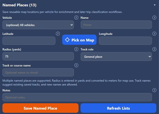
The observed version enters radii in yards and converts them to meters for map use. Follow the unit shown next to the field in your installation. A wider radius accepts points farther from the center and can overlap nearby locations; choose a radius appropriate to the place.
| Role | Use |
|---|---|
| General place | An ordinary reusable location. |
| Track start | Start location for a track or course. |
| Track finish | Separate finish location. |
| Track start / finish | A shared start and finish location. |
| Track split / timing point | An intermediate timing location. |
| Drag start | Start location for drag analysis. |
| Drag finish | Finish location for drag analysis. |
| Other track location | Another location associated with a track. |
Use the same Track or course name for related markers. The field suggests existing track names and also accepts a new name. These roles identify locations; do not assume they are a complete racing configuration or a physical line measurement.
The saved table shows name, scope, location, radius, role, track, and actions. Choose Edit for the entry you want to change, update its fields, and save. Use Cancel Edit to abandon the edit. Refresh Lists reloads the saved list.
The map toolbar's named-place pin shows or hides the place overlays. Place details can expose private locations, so the public screenshots omit the saved-location table.
See Reports for Named Places and Racer Report options, and Trip Tags for classifying trips independently of their locations.