-
Notifications
You must be signed in to change notification settings - Fork 29
Prototypical City
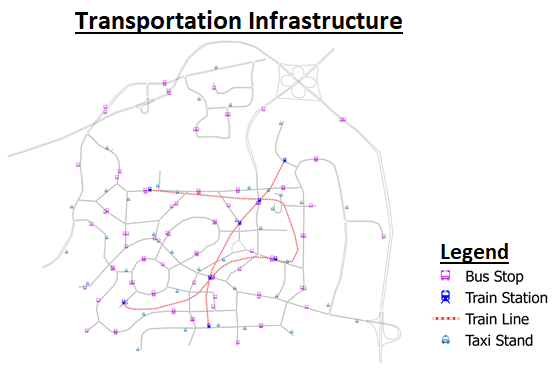
Prototypical City is a simplified prototype of a city, openly distributed by SimMobility. It is intended for use by the public, private, people and research sectors. It provides a friendly and open platform for modelling and simulation needs in order to solve emerging and complex challenges for future mobility. This prototypical city comprised detailed information such as transportation network, transportation infrastructure (such as bus stops, train stations, taxi stands), postcodes, buildings, etc. Prototypical City was constructed by a transportation network with structure and detail suitable for medium-/short-term modeling. Next, a hypothetical set of residential, building was populated and followed by the assignment of jobs, households, and establishments.
A city with dimension (13 km x 11.5 km), there are 24 Traffic Analysis Zone (TAZ) with varies in size, ranging from large areas in the exurban to small areas in central business districts. Besides, it has 10% of Singapore's population (~100K HHs). The following maps show the population, households, establishments and schools in the Prototypical City.
The transportation network of Prototypical City contained: 95 nodes, 254 links, 79 bus stops, 10 bus lines, 8 train stations, 4 train lines and 38 taxi stands. The below maps show the transportation network and infrastructure of Prototypical City.


