Repository navigation
SatMe PC Map and space weather
← SatMe-PC guide · October 2026
The shared map, without Internet; ADS-B (1090 MHz) and aircraft scatter; AIS (162 MHz); NOAA's space weather. Aircraft and ships are non-satellite functions, shown only once ticked (Réglages › Modules). Everything is reception only.
Where: Ciel workspace › Carte. The layers are ticked at the top: Satellites, APRS, Sondes, Avions (ADS-B) (aircraft), Navires (AIS) (ships), Stations DATV, Locators contactés (worked locators), Ma station (my station), Jour et nuit (day and night), Aurore prévue (forecast aurora), Diffusion par avions (aircraft scatter); Cercles (rings; 100 to 1000 km); Fond OpenStreetMap (Internet) (OpenStreetMap background). Drag, wheel; a click on an object gives its details.
The shared map, without Internet (SatMe's own coastlines). Layers: satellites (footprint, ground track), APRS, the followed sonde, aircraft, ships, DATV stations whose locator is known, worked locators, your station, day and night, the forecast aurora, aircraft scatter, range rings. Fond OpenStreetMap (unticked by default): tiles loaded by the browser, nothing goes through SatMe-PC.

Where: Ciel workspace › Avions (shown only if Réglages › Modules › Avions is ticked).
The Avions tab receives ADS-B on 1090 MHz (2 MS/s), off until Recevoir (receive) is clicked. Reception only.
-
Receiver: the SDR tab's dongle (taken only on Prendre la clé (take the dongle), the SDR tab then no longer starts on it), a second dongle (its own rtl_tcp,
-dindex or serial, on its port), or the ADALM-PLUTO (never taken from DATV or transmission). Gain, réparer 1 bit faux (single-bit repair). - The aircraft list: ICAO, callsign, altitude, speed, track, position, distance and azimuth, last seen, messages, RSSI.
- SBS-1 output (« MSG,… » text lines) on 127.0.0.1:30003, off by default, for other programs on this PC.
- Aircraft scatter (a forecast, nothing is transmitted): a partner by callsign or locator, a band (10 GHz, 13 cm, 23 cm, 2 m), a radius, a horizon in minutes, both stations' heights and a minimum altitude. Each aircraft is extended in a straight line: the window is the time it spends in the common volume both stations see (radio horizon, 4/3 earth), with its duration, altitude, elevations and Doppler. A message when a window opens.

Where: Ciel workspace › Navires (shown only if Réglages › Modules › Navires is ticked).
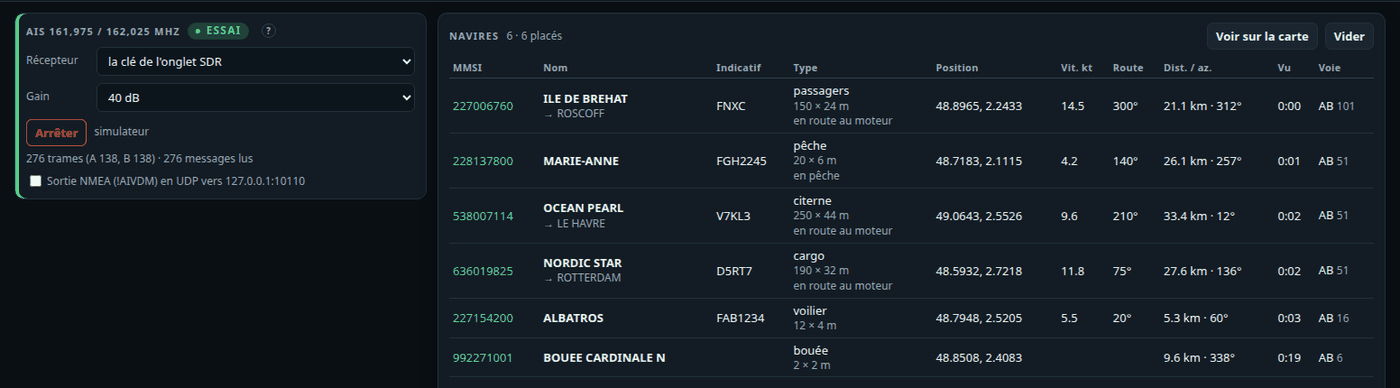
The Navires tab receives AIS on 162 MHz, off until Recevoir is clicked. Reception only.
- Both channels (161.975 and 162.025 MHz) from one dongle at 288 kS/s: position, voyage, class A and B, beacon and aid-to-navigation messages (ITU-R M.1371).
- Receiver: the SDR tab's dongle (taken only on request) or a second dongle (its own rtl_tcp). AIS never takes the ADS-B's dongle, nor the other way round.
- The list: MMSI, name, destination, callsign, type and size, position, speed, course, distance and azimuth, last seen, channels; Voir sur la carte (show on the map).
-
NMEA output (
!AIVDMlines over UDP to 127.0.0.1:10110), off by default, for a navigation program on this PC. - Essai (test): simulated ships around the station.
Where: Ciel workspace › Météo spatiale. Tick Récupérer la météo spatiale (Internet) (fetch the space weather); Mettre à jour (update); Dire les alertes à voix haute (ce navigateur) (say the alerts aloud, this browser).
The Météo spatiale tab: what is needed to judge propagation and aurora.
- Nothing is downloaded until Récupérer la météo spatiale (Internet) is ticked. Only then are NOAA's public products (services.swpc.noaa.gov, and that host only) fetched every 15 min (aurora every 30 min) and kept on disk; at start the kept copies are shown with their age.
- Kp index on a gauge, its bars over three days (observed and forecast), the 10.7 cm solar flux (offered to the Sun noise measurement), X-rays (GOES) over 6 h, the solar wind (speed, Bz, Bt), the forecast aurora (OVATION) here and within 1200 km, and its oval on the map.
- Alerts: geomagnetic storm (Kp ≥ 5) and solar flare (≥ M5), with what they change for operating; said aloud if ticked.
